Reconstructing and reviewing World Trade Center Towers collapse events
The events of 9-11-01 are truly unique as an historic event in that much of them were filmed. At no other time in recorded history was an initiating event for a series of wars been caught so carefully on film. This unique opportunity allows anyone that has access to a visual record sufficiently complete to be able to cross-check claims by any government, organization or individual now and in the future.
Earlier records and descriptions of the WTC1 and 2 collapses prior to 2009 were limited by a video and photographic record available to the public which was poorly assembled and poorly interpreted. Those initial limitations were overcome by 2010 and 2011 with visual reconstructions of the collapses progressions throughout each tower. For the first time all researchers, including those who have worked for the NIST during the investigations, can see a reconstructed visual mapping of each building which pretty much removes all doubt as to what the actual collapse mechanisms were.
The first direct visual mapping of movement of the WTC towers gives people an excellent opportunity to check their previous and current models of the object against the visual mapping to see if the models were correct or incorrect. It allows one to independently fact-check claims made by any party by direct observation and measurement. It also allows a fact-checking of ones own views as pre-conceived notions one has would be directly challenged by the visual record.
VISUAL RECONSTRUCTIONS OF THE COLLAPSE PROCESSES
The approach this author took toward a review and verification of all claims concerning WTC1 and 2 is quite simple.
First, Gather the largest and most complete visual record1 possible.
Second, Re-construct the events:
1) Collapse progression: The visual record is re-viewed and reconstructed to determine the collapse mode and global mass flow.
2) Detectable deformation into the collapse initiation sequence: With the visual record and knowledge of the collapse dynamics, the initiation sequences and movement leading up to them are reconstructed and mapped.
3) The aircraft impacts and the resulting fires.
4) The debris layout and condition.
Third, The observations and measurements obtained are used to fact-check claims by official and non-official sources.
With the first step a complete library is formed. As is demonstrated in this website, the explanations for both collapse progression and collapse initiation of all 3 collapsed buildings are verifiably incorrect. Without the formation and analysis of independent visual libraries of the events, the current explanations could never have been examined and cross-checked.
With the second step, the first comprehensive visual record and mapping of the collapse progression and collapse initiations of all 3 towers was assembled. The collapse initiation sequences and the events leading up to them are also extracted from the visual record using as much visual and measurable evidence as possible. The aircraft impacts are also reconstructed as completely as possible to check the impact angle and building features during impact. The resulting debris layout is also recorded and grouped according to region.
The third step uses the reconstructed events and mapping of the rubble condition and distribution to independently verify or refute various claims made about the collapses. Many of the resulting observations do not appear in any official or academic reports or papers on the collapses. Some of the observations and measurements directly contradict the official descriptions of the collapses.
A large body of photographs of the events at the World Trade Center complex on 9-11-01 are available divided into 3 main groups in the following categories.
1) General photos of the airplane impacts to the collapses:
WTC1 Attack to Collapse
WTC2 Attack to Collapse
WTC 7
2) Time-sequenced photos of the fire progression of each face WTC1 and WTC2:
Fire Progression, WTC1 North Face
Fire Progression, WTC1 South Face
Fire Progression, WTC1 East Face
Fire Progression, WTC1 West Face
Fire Progression, WTC2 North Face
Fire Progression, WTC2 South Face
Fire Progression, WTC2 East Face
Fire Progression, WTC2 West Face
3) Photographic record of the debris condition and distribution after the collapses
where all photographs of debris are grouped by region as shown in the image below.
All photographs of the debris are grouped according to location and type.
It is hoped that by rearranging all known useful debris photos by region, the reader can see for themselves how debris was distributed throughout the complex and in what condition without being overwhelmed with too much confusing information.
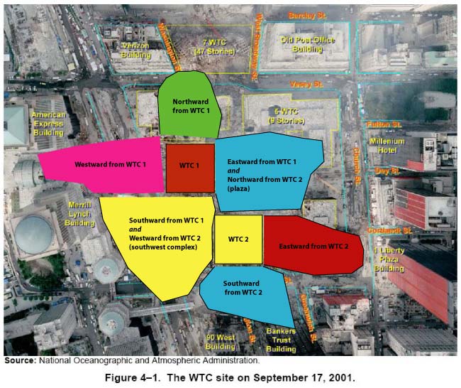
Southward from WTC1 and westward from WTC2 share a region (we'll call it "southwest complex") and eastward from WTC1 and northward from WTC2 share a region (the plaza area). Hence 8 natural regions total.
All debris photos are divided into the following categories
Debris grouped by location:
Debris: WTC1 Around Footprint
Debris: WTC2 Around Footprint
Debris: From WTC1 Westward
Debris: From WTC1 Northward
Debris: From WTC2 Eastward
Debris: From WTC2 Southward
Debris: Plaza Area, Northeast Complex
Debris: Hilton Hotel, Southwest Complex
Debris: General, Unidentified Locations
Damage to Surrounding Buildings
Debris grouped by type:
Perimeter Column Photo Record
Perimeter Columns: Types of Damage
Core Box Columns: Types of Damage
________________________________________________________________________________________________________________________
1 All publicly available videos of the World Trade Center events of 9-11-01 are available through 3 sources:
Femr2 video library
Xenomorph video library
and
ConspiracyTV:
WTC1 video archive
WTC2 video archive
WTC7 video archive
Many other sources are available, but these 3 sources alone provide a comprehensive and informative library of video evidence.